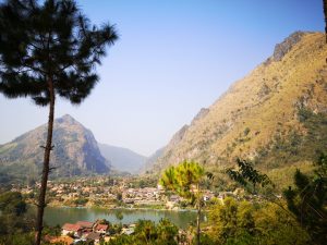
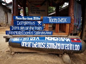
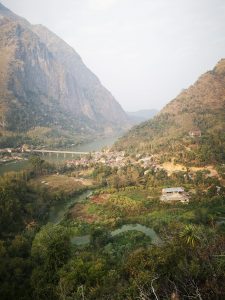
 Nong Khiaw in northern Laos, can be reached from Luang Prabang in under four hours by minivan. Situated on the Nam Ou River and surrounded by karst, limestone mountains, it’s the type of place where you’ll book to stop for one night, but find you’ll stay for a week or longer. It’s in a beautiful and tranquil location. Hard to believe that these peaks were bombed heavily in the Vietnam War. 580,000 bombing missions over nine years, that’s a bomb dropped every eight minutes 24 hours a day for nine years. Unexploded ordinance (UXOs) are still being found in Laos and it’s wise to stick to the trekking paths in remote areas.
We book for one night into the Viewpoint Resort, a guesthouse of ten rooms, set above the village and away from the bars, boats and cockerels, so a good night’s sleep is assured. It is such a delightful place with a stunning view from balconies and shared terraces, perfect for reading and relaxing, that we end up staying a week. One of my favourite weeks of five months in South East Asia.
 There’s much to do in the area. Boat trips, kayaking, hiking, zip lining, home stays. But we’ve done much of that recently with less tourists in more remote areas of Myanmar and I must say, for half the price being charged in Laos. We don’t feel the need to go out with a tour guide, as there are six magnificent climbs to spectacular viewpoints in the village, where there’s no need for a guide and the cost to climb is practically nothing. The fee charged by the local Lao licence holders (who must maintain the paths and cliff top viewing platforms) is no more than 20,000 kip (£1.80) per person.
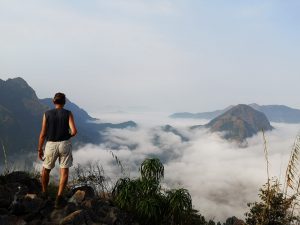
I consider this the best bargain in Laos. Incredible value made more so as the views are some of the best I’ve seen in Indochina. And there’s barely anyone on the peaks, despite them being accessible to anybody with a reasonable level of fitness.
 As budget travellers, we have often found that the cost to visit protected forests, nature reserves or bird watching areas are beyond our means, regularly $60 – $150 per person per day. In a world where the Lonely planet guide has quashed the chances of being lonely, particularly anywhere beautiful and in a world where tranquil scenes of nature seem increasingly exclusive for the wealthy, I’m heartened to find there’s still a chance of solitude and natural beauty on a budget in South East Asia. We can enjoy breathtaking views and stunning landscapes in peace, without the hordes and without it costing the earth in Nong Khiaw.
This website is not intended to be a travel guide. There’s plenty of those available in bookshops and online. It’s a warts and all record of our travel experiences, a collection of travel stories and hopefully an enjoyable read. However, we were surprised that we could find little information about the climbs, so I’ve added a few extra details to my record of the hikes, to assist any readers that are visiting the area. Times dependant on ability and do not include time spent on the summits.
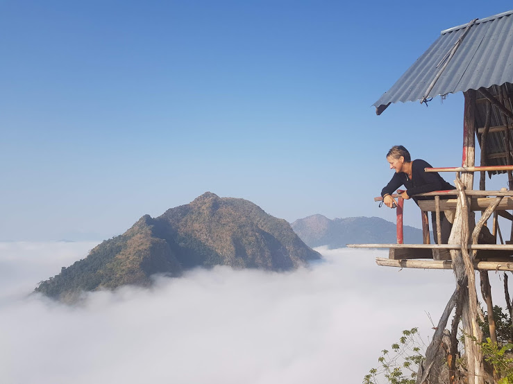
 In my opinion, it is essential to reach all the peaks, except for Phanoi, by 9am, before the clouds of mist disperse.
There seems to be some variation in the names given to the Viewpoints, so for the sake of consistency, I am using the titles which the locals have used to label their Viewpoints.
We pack plenty of water, insect repellant and a fleece pullover. A picnic breakfast, a bag for rubbish which we will later dispose of at our accommodation, the fee of 20000 kip per person and a camera to record the stunning views. We were glad of our good walking shoes and our bamboo walking poles.
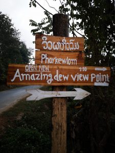
Pharkewlom
Info: Height 1088m. Ascent 2 hr. Descent 2 ½ hr. A challenging, natural hike.
 It’s dark and silent at the hotel at 630am when the night manager scoops up a bag from the fridge containing a picnic breakfast bag of boiled eggs, bread, jam and fruit. Packing this and water into our rucksacks, we quietly put on our walking shoes and head down the hill to the road beneath the Viewpoint Hotel and turn left, out of town, towards the town campsite and swimming pool.
900 metres along the road, after the kiosk for Pha Daeng Viewpoint, but before the swimming pool, is a kiosk on the right with a signpost, Pharkewlom, amazing dew viewpoint.
It is attended by a young woman and her child and we pay 20000 kip (£1.80) each to start the climb.
 It’s 650am. The mountains are invisible, enveloped in clouds of mist. I can see the moon peeping through and it’s one of those beautiful moments, frustratingly impossible to capture by camera. We cross a bamboo bridge over a fast flowing stream and make our way across farmland past water buffalo and cattle to the base of the mountain. Immediately we are climbing a very natural and covered path of earth and rocks under tall trees, interspersed with a series of bamboo ladders and gangways.
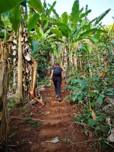
After 45 minutes, there’s a break and the landscape opens up to reveal a banana plantation with a flight of ochre coloured earth cut steps and some interesting funnel style spiders webs. After an hour walking we reach a sign that reveals we are at the halfway point. There’s a huge, dark fallen tree that acts as a bridge across a gorge and another series of ladders to climb before we reach the peak at 945am.


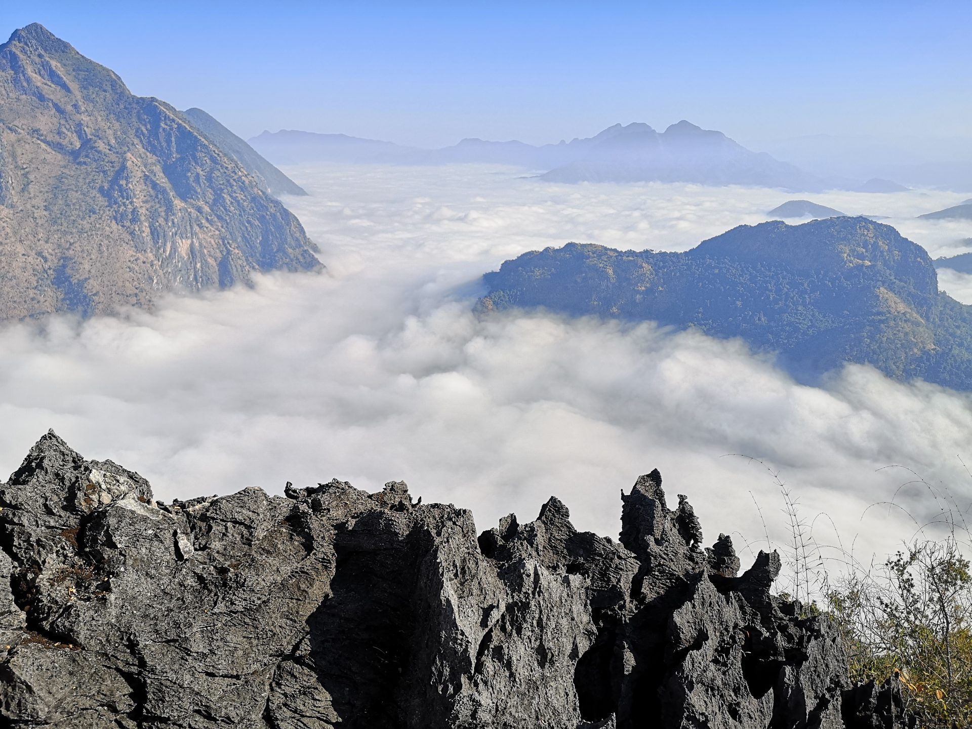
The viewing platform is set upon sharp volcanic rock. We stand spellbound in silence. It’s just us at the top and the view over the clouds is exceptional. I feel quite emotional. We soak up the scene. We attempt a selfie and fail.
I can’t think of a better place that I’ve stopped for a picnic. Enjoying our packed breakfast of boiled eggs, bread and fruit in solitude on the peak, I’m reminded of Scotland. This peak is 1088m. In Scotland, any mountain over 1000m is called a Munro after Sir Hugh Munro, who produced the first list of such hills in 1891. Read More: https://getrealtravel.com/europe/scotland/bagging-a-munro/


We wait until the clouds disperse before slowly making a descent. The earth is loose and covered in leaf litter making it slippery and we don’t underestimate the challenge of the descent with our combined age of 111 years and with my knees still suffering arthritic type pain, the result of the Chikungunya virus picked up from a mosquito in Myanmar six weeks ago. It takes us 2 ½ hours to descend safely.
Phakhao
Info: Height 1063m. Ascent 2hr. Descent 2hr. A strenuous, fairly manufactured hike.
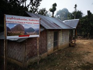 It’s 650am. Not as misty as it has been over the last few days, but it’s still quite thick along the river valley. Opposite the road which climbs to Viewpoint Resort is a sign which points down a dusty lane to Phanoi and Phakao Viewpoints. The lane is set between homesteads with hens, chicks and cockerels pecking around the grassy verge. Local women are stoking their stoves ready to cook up breakfast. As we approach the rustic kiosk which marks the start of the hike, one of the women calls out which causes another to rush from her home to meet us.
We pay 20000 kip each, approximately £1.80 and receive a ticket. The kind faced woman points to a collection of bamboo walking poles and offers us their use. Armand already has his, so it’s just one for me to borrow. It’ll help knee stability on the ascent.
We start at 7am and walk past pigsties down to a bamboo bridge to cross a pretty tributary surrounded by farmland. On the far side we take the first flight of thirty, manageable, ochre coloured, earth, cut steps to which there will be many more to follow. This climb is basically a step challenge. It’s lucky I like taking the stairs rather than taking the elevator and I’ve recently had much step practice next to the river in Loboc in the Philippines.
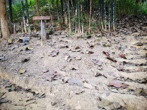 Treading the same path as for tiny Peak Phanoi, we pass teak trees and walk on for fifteen minutes, until there is a signpost directing us left for Phanoi. We ignore this left branch today and continue uphill to the high peak of Phakhao.
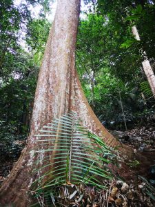
Forty minutes from the start of the walk, we have climbed at least 1500 earth cut steps, passing banana trees and huge leaf litter before the path takes a more interesting diversion to snake around a rock face and past fine, tall trees with buttress roots.
 There’s another 400 or so steps of varying depths until there’s a break in the vegetation revealing thick cloud cover and we stop for water. Ahead as we continue to climb, there’s a series of ladders to assist us over steep rock formations and a further 100 or so steps.
Ninety minutes since commencing the hike, we reach a flight of 400 earth cut shallow footholds and we notice the breeze and a rustling of leaves. This is Phakhao. I am given to understand that Pha means Peak and Khao means ‘always windy’. This peak does seem to catch the wind and I’m glad I have a fleece in my rucksack. My shirt is soaking in sweat from the hot and strenuous step climb, but I know from my experience of running, that I’ll get cold quickly when I stop the exertion. It will be cool at the top of breezy Phakhao.
Another 500 or so, earth cut steps and we reach the rocky peak and scramble along a stone and earth path to the bamboo and corrugated metal roofed viewing platform. On the cliff edge, there’s a second timber platform with the Laos flag flapping furiously in the wind. It’s 9am. This climb has taken exactly two hours. We swiftly replace our damp tops for fleece jumpers and admire the view. The clouds of mist are not so dense today, but it’s still a fantastic view through the clouds to the river and the village below. We quickly eat our packed picnic breakfast on the cold, windy viewpoint and again I’m reminded of Scotland. This is another Munro in Laos.


In just forty minutes, we are cold and at 940am we descend. Making our way down the steps, we pick our way carefully. It would be easy to slip on the loose earth and leaf litter. It doesn’t take long before we warm up and need to remove our thick tops and swap back to damp shirts. The day is heating up fast and it will soon be 30 degrees. We haven’t seen a soul, but near the bottom of the climb, at about 1130am, we meet a Thai couple and a couple of young women from Belgium. They are already sweltering and ask how long it is to the top. When we tell them it will take about two hours, the Belgians consider diverting to the path for the lower viewpoint of Phanoi.
We return to the road and remember that we have another 130 steps to climb to our guesthouse opposite, but will be rewarded with another super view and a glass of beer.
Nang None Mountain, Sleeping Woman Viewpoints (SWV) 1 and 2
Info: Height to SWV 2, 731m. Ascent to SWV 2, 60 minutes. SWV 2 to SWV 1, 35 minutes. Descent from SWV 1, 60 minutes. Strenuous. Most likely climb in Nong Khiaw to induce vertigo. No smoking because of tinder dry bamboo leaf litter and a risk of fire.
At 720am, we collect a packed breakfast from Viewpoint Resort Hotel, walk down to the road below and turn right towards the bridge. The river is shrouded in mist. It’s a 1.6km walk north, over the bridge and out of town, past small teak plantations, towards the Hive Bar and the start of the hike. The kiosk and a sign for Nang None Mountain Viewpoints is set off the main road to the right within a pretty and well tended garden. The fee for this route is 15000 kip, approximately £1.30 each and both viewpoints initially share the same path.


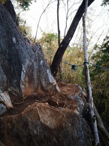 It’s 0745am. Climbing up and over rocks there’s the occasional daub of concrete to create a secure foothold step and handrails of bamboo or plastic cable in place to assist the ascent. We pass some fine trees with huge buttress roots as tough as rock which we scramble over and after approximately forty minutes from the start, we reach a junction and signpost. Viewpoint 1 to the left is the lower viewpoint and we decide to go first to the right, to the higher platform, viewpoint 2. Within ten minutes, we are undertaking vertical climbs assisted by bamboo ladders over ochre coloured earth and rocks to traverse around the side of the rockface upon a narrow and vertigo inducing path. Continuing, we make a final scramble over sharp rocks to reach the roughly made and basic viewpoint structure which hangs precariously over the drop with only a knee-high rail as a barrier. It’s in need of some maintenance and we notice timber nearby, so guess it’s a work in progress.


The short (0.7 mile) but strenuous climb has taken an hour and the view is breathtaking. At 0845am, we are still above a thick sea of cloud, between the mountains. My camera thinks it’s recording snow. It is one of the best views I have seen in Indochina and we are alone to enjoy it. No need for a guide and at a cost of only £1.30, it’s incredible that people are spending a fortune on tours when these viewpoints are available for hiking. We spend a good 45 minutes enjoying the view, (including that of the platform, Sleeping Woman 1 below us), before retracing our steps carefully to the junction where we take the path to Viewpoint 1.
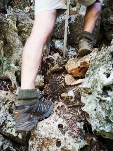 No need for ropes or a bouldering mat, but the path changes into somewhat of a rock climb and it is easy to lose sight of the way. We keep scrambling up the loose rocks and find a bamboo ladder kindly placed strategically on the route to assist us.
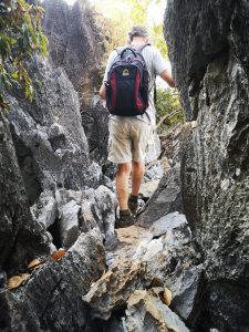 There’s a short stretch where the path narrows and we squeeze between pinnacles of rock before we reach the viewing platform. It’s only taken fifteen minutes from the junction to viewpoint 1, but it’s been tricky.
Here we finally find that we are not alone on this mountain. A young tour guide has popped up to the platform to enjoy the view and to brew up a coffee. We chat and share our breakfast. The clouds have dispersed and we can see the river and the town below and above us, Sleeping Woman Viewpoint 2, where we had just sat above the clouds. It takes us an hour to descend and return to the road.
Pha Daeng
Info: Height 460m. Ascent 1 hr. Descent 1 1/4 hr. Moderate hill walking.
 This viewpoint is in the guidebooks and reviewed on Tripadvisor. I hear that the local Lao, who managed to get a twenty year licence to sell tickets for this climb, is a very happy man. Many visitors take his path and he is doing rather well. This will not be a solitary hike. There will be no avoiding tourists, but at about an hour to ascend, it will be a good test of our condition to establish our durability for the other hikes in the area. The kiosk opens at 6am and gets a steady stream of visitors from that time.
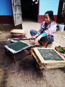 We start our walk after breakfast at 745am. South from the bridge and along the main road, we go past the lane on the right to Phanoi and Phakhao Viewpoints. We walk another five minutes, along the road, until we see on the left, the colourful sign for Pha Daeng Viewpoint. In front of the kiosk is a casing of a bomb from the Vietnam War and a painted warning that we are to keep to the path. We pay 20,000 kip per person, approximately £1.80 each, and start a steady climb past cockerels, spider’s webs and women making a local delicacy, a thin cracker of Mekong river weed. We climb earth cut steps which are later edged with bamboo and where the path gets tricky over rocks and loose ground, there are bamboo handrails. The path winds and climbs to some delightfully positioned swings, which make for a brief diversion and turns us into children for a moment. The track is well maintained and manageable with some exertion.
At 845am, we reach the rocky summit and the substantially built viewing platform which is more of a concrete and brick terrace than a platform. It is surrounded by a wall and has seating and signage indicating that camping upon the platform can be arranged via the licence holder.
The view over the clouds of mist reaching between the mountains is a good reward for our efforts. Nearby rocky pinnacles have been worn to allow the perfect position for a photo next to the summit flag, but there’s a queue of fellow tourists and we wait our turn for a shot. We realise that we are lucky. 845am, is just about the latest time to reach the submit and still see the sea of clouds as they are now swiftly dissipating to reveal the view of the town and our hotel below. By 930am, we still have a good view, but it’s not as dramatic.


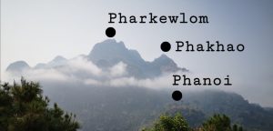
Armand has his binoculars and spies two higher viewing platforms in the mountains to our left. I notice two lower platforms on a rocky outcrop in the mountains across to our right. I get chatting to the crowd on the peak and no one has any knowledge of these viewpoints. A young German girl tells me that she is a little frustrated. If she knew how long they took to climb, she might be able to enjoy another hike before she leaves tomorrow. I am seized with the desire to get to all the Viewpoints and to write a little about them.
We slowly descend, my weak knees still affected by Chikungunya. Blast that mozzie! I am able to ascend, but descents seem to cause difficulties. It takes me over an hour to return to the road and I am regularly overtaken by young walkers who hop down the earth cut steps like mountain goats. My lack of condition is frustrating, but it’s OK. Thankfully, my ailment should not last forever. Another few weeks and I hope to be pain free.
Phanoi
Info: Height 430m. Ascent 26 minutes. A pleasant walk.
This viewpoint is the lowest in Nong Khiaw and often consumed by thick cloud cover in the morning. We want to see a view, so we start this walk at 430pm for sunset. South of the bridge, opposite the road on the left which climbs to Viewpoint Resort is a sign directing us along a lane to Phanoi and Phakhao Viewpoints. It’s a small, dusty lane set between homesteads with hens, chicks and cockerels pecking around the lane’s verges. Pigs are being fed in their raised, wooden sties. The kiosk at the start of the climb is empty, but a man appears from a house and relieves us of 20000 kip (£1.80) each.


 We walk down to a bamboo bridge to cross a pretty tributary surrounded by farmland. On the far side we take the first flight of thirty, manageable, ochre coloured, earth, cut steps. Passing teak trees and climbing another flight of foothold steps, we reach a signpost and are directed left to Phanoi. A winding path continues to a bamboo ladder which assists us to the viewing platform. In just 26 minutes, we are enjoying the view as the sun sets. There are signs of recent maintenance. The site is a little scruffy as vegetation has recently been cut and burnt to maintain the view. Beyond the site, the view of the tributary, the Nam Ou river and the surrounding mountains is delightful. We get another vista of our guesthouse, aptly named Viewpoint, positioned on the hill opposite beneath the karst mountains.
As it begins to get dark, we return following the same route.
Returning to the kiosk we leave our bamboo walking poles as this is our last climb for now in Nong Khiaw. I feel a sense of sadness. These peaks, these viewpoint climbs have been one of the highlights of my trip to Laos and I could easily stay longer in this area. Here’s balance. A place to kick back and relax, and a place to keep active surrounded by nature. Lets hope it stays this way.
Find out more:
Viewpoint Resort, Nong Khiaw: Visit:https://www.facebook.com/View-Point-Hotel-Resort-Nong-Khiaw-Laos-157099804400180/
Nong Khiaw: https://getrealtravel.com/asia/nong-khiaw-on-the-nam-ou-river-laos/
Bagging a Munro, Scotland: https://getrealtravel.com/europe/scotland/bagging-a-munro/
Chikungunya, a mosquito borne virus: https://getrealtravel.com/asia/medical-treatment-at-a-yangon-clinic/
Loboc, Philippines: https://getrealtravel.com/asia/bohol-loboc-river-rajah-sikatuna-national-park/
It all looks so amazing.
Very useful! Thank you
Glad you enjoyed it. Thank you very much for the feedback!
brilliant read, very exhaustive and great experiences shared. I’ll be doing some of these climbs tomorrow
We just completed the sleeping woman overlook 2. They must have improved the trail, as there we no ladders, only steps. At no point was there any worry. It’s a steeper hike, but was a good morning workout. We enjoyed the view and spent about 2 hours round trip.
Thank you for this post. It was very helpful and informative. I did forward this to folks who were trying to figure out which one to hike. I enjoyed Pharkewlom the most.